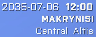
Arma 3のキャンペーンで登場したshowOSDという機能を使用し、自動で日時や場所を挿入して画面右下にタイピング風文字を出現させよう!
- functionsというフォルダを作成し、中へ“fn_showOSD.sqf”を作成
- “fn_showOSD.sqf”へ下記の構文をコピペ
- 更に“titlecall.sqf”を作成し、中身に下記の構文をコピペ
- Description.extへも下記の構文をコピペ
- init.sqfにも下記の構文をコピペ
[] call TAG_fnc_showOSD;
titlecall.sqf
/*
Author: Jiri Wainar
Description:
Display OSD with location, time and possibly some other campaign related info.
Parameter(s):
_this select 0: array (optional) - position (default: player's position)
_this select 1: array (optional) - date in format [_year,_month,_day,_hour,_min] (default: current date)
Example:
[] call BIS_fnc_camp_showOSD;
Returns:
- nothing -
*/
private["_fn_getSector"];
_fn_getSector =
{
private["_map","_posX","_posY","_gridX","_gridY","_secWidth","_secHeight"];
private["_bottomLeftX","_bottomLeftY","_topRightX","_topRightY"];
_map = toLower worldName;
if !(_map in ["altis","stratis"]) exitWith
{
-1
};
if (_map == "stratis") then
{
_bottomLeftX = 1302;
_bottomLeftY = 230;
_topRightX = 6825;
_topRightY = 7810;
}
else
{
_bottomLeftX = 1765;
_bottomLeftY = 4639;
_topRightX = 28624;
_topRightY = 26008;
};
_posX = _this select 0;
_posY = _this select 1;
//check if player is outside the map grid
if !(_posX > _bottomLeftX && _posX < _topRightX && _posY > _bottomLeftY && _posY < _topRightY) exitWith
{
0
};
//offset player pos to [0,0]
_posX = _posX - _bottomLeftX;
_posY = _posY - _bottomLeftY;
_secWidth = (_topRightX - _bottomLeftX)/3;
_secHeight = (_topRightY - _bottomLeftY)/3;
_gridX = floor (_posX/_secWidth);
_gridY = floor (_posY/_secHeight);
((_gridY * 3) + _gridX + 1)
};
private["_position","_date","_output","_showDate","_showLocation","_showMap"];
private["_tLoc","_tMap","_tDate","_tTime","_tTimeH","_tTimeM","_tDay","_tMonth","_tYear"];
_showDate = true;
_position = [_this, 0, getPos player, [[]]] call BIS_fnc_param;
_date = [_this, 1, date, [[]]] call BIS_fnc_param;
_tMap = [_this, 2, "auto", [""]] call BIS_fnc_param;
_tLoc = [_this, 3, "auto", [""]] call BIS_fnc_param;
if (_tMap != "") then
{
_showMap = true;
}
else
{
_showMap = false;
};
if (_tLoc != "") then
{
_showLocation = true;
}
else
{
_showLocation = false;
};
//get map text
if (_showMap && _tMap == "auto") then
{
private["_sector","_map","_template"];
_sector = _position call _fn_getSector;
if (_sector == -1) then
{
["Map not recognized! Only 'Altis' and 'Stratis' are supported."] call BIS_fnc_error;
_showMap = false;
_showLocation = false;
};
_map = gettext (configfile >> "cfgworlds" >> worldname >> "description");
_template = switch (_sector) do
{
case 1: {localize "STR_A3_SectorNorthWest"};
case 2: {localize "STR_A3_SectorSouth"};
case 3: {localize "STR_A3_SectorSouthEast"};
case 4: {localize "STR_A3_SectorWest"};
case 5: {localize "STR_A3_SectorCentral"};
case 6: {localize "STR_A3_SectorEast"};
case 7: {localize "STR_A3_SectorNorthWest"};
case 8: {localize "STR_A3_SectorNorth"};
case 9: {localize "STR_A3_SectorNorthEast"};
default
{
_showLocation = false;
//hardcoded for Stratis and Altis only
if (worldname == "Stratis") then
{
localize "STR_A3_NearStratis"
}
else
{
localize "STR_A3_NearAltis"
};
};
};
_tMap = format[_template,_map];
};
//get current location text
if (_showLocation && _tLoc == "auto") then
{
private["_locations","_loc"];
_locations = nearestLocations [getPos player, ["NameCity","NameCityCapital","NameLocal","NameMarine","NameVillage"], 500];
//filter-out locations without names
{
if (text _x == "") then
{
locations set [_forEachIndex, objNull];
};
}
forEach _locations; _locations = _locations - [objNull];
if (count _locations > 0) then
{
_loc = _locations select 0;
if ((getPos player) in _loc) then
{
_tLoc = text _loc;
}
else
{
_tLoc = format[localize "STR_A3_NearLocation", text _loc]; //tolocalize: "Poblíž lokace %1"
};
}
else
{
_tLoc = "";
_showLocation = false;
};
};
//get daytime data
_tYear = _date select 0;
_tMonth = _date select 1;
_tDay = _date select 2;
if (_tMonth < 10) then {_tMonth = format["0%1",_tMonth]};
if (_tDay < 10) then {_tDay = format["0%1",_tDay]};
//get date text
_tDate = format["%1-%2-%3",_tYear,_tMonth,_tDay];
//get time text
_tTimeH = _date select 3;
_tTimeM = _date select 4;
if (_tTimeH < 10) then {_tTimeH = format["0%1",_tTimeH]};
if (_tTimeM < 10) then {_tTimeM = format["0%1",_tTimeM]};
_tTime = format["%1:%2",_tTimeH,_tTimeM];
//sum the output params & print it
_output =
[
[_tDate,"%1 ",0],
[_tTime,"%1
",5]
];
if (_showLocation) then
{
_output = _output + [[toUpper _tLoc,"%1
",5]];
};
if (_showMap) then
{
_output = _output + [[_tMap,"%1
",30]];
};
[_output,-safezoneX,0.85,"%1 "] spawn BIS_fnc_typeText;
class CfgFunctions {
 class TAG {
  class MyMission {
   class showOSD { file = "functions\fn_showOSD.sqf"; };
  };
 };
};
_null = [] execVM "functions\titlecall.sqf";
サンプルのダウンロードはこちらから
rayさんありがとうございました。


すばらしい。
返信削除